Ponieważ zbliża się 74 rocznica Powstania Warszawskiego chciałbym pokazać Wam kilka wybranych zdjęć porównujących te same miejsca wtedy i dziś. Pokazują one nie tylko skalę zniszczeń wojennych ale także to jak bardzo w ich wyniku to Miasto zmieniło się…..

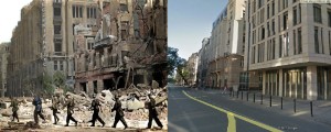
Ul. Jasna, w tle widać wylot ul. Boduena i narożną kamienicę Seydenbeuthlów, która parę lat temu została odnowiona. Na prawo od niej w miejscu kamienicy Domu Dochodowego Warszawskiego Towarzystwa Ubezpieczeń od Ognia (Boduena 3/5 róg Jasna 4) stoi Naczelny Sąd Administracyjny.

Ul. Jasna róg Świętokrzyskiej, po lewej widać gmach Poczty, w czasie Powstania siedziba dowództwa Armii Krajowej i szpital polowy.

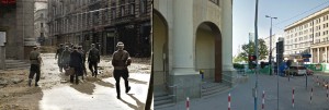
Wylot ul. Wilczej do Marszałkowskiej. Barykada powstańcza.

Długa / Miodowa. Po prawej znajdował się właz do kanałów, skąd Powstańcy przedzierali się do Śródmieścia (wychodzili na Nowym Świecie przy ul. Wareckiej – polecam spacer tym szlakiem, przekonacie się jak długo to odcinek…)

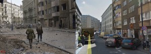
Koszykowa, w tle ul. Mokotowska, ten odcinek ulicy zachował się w dużej części…

Czego nie można powiedzieć o Koszykowej biegnącej w kierunku wschodnim… Jej ciąg po wojnie został przerwany przez Plac Konstytucji.

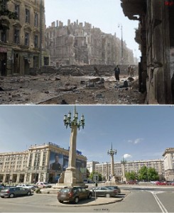
To zdjęcie pokazuje nieistniejące już ulice… Barykada na ul. Siennej w ciągu ul. Wielkiej. W tle widać okazały budynek wydawnictwa Gebethner & Wolff, już wcześniej opisywany przeze mnie. Teraz to Plac Defilad..
Kolorowe zdjęcia z Powstania Warszawskiego Muzeum Powstania Warszawskiego, fot: Wiesław Chrzanowski ‚Wiesław’/ Mikołaj Kaczmarek – Kolor Historii
As the 74th anniversary of the Warsaw Uprising is approaching, I would like to show you some selected photos comparing the same places then and today. Not only do they show the scale of war damage, but also how much the City has changed as a result of it…

Jasna Str. in the background you can see Boduen Str. and the corner tenement house of Seydenbeuthl, which was renovated a few years ago. To the right of in the place of the tenement house Boduen Str. 3/5 corner of Jasna Str 4, there is the Supreme Administrative Court.

Jasna Str. corner of Świętokrzyska, on the left you can see the building of the Post Office, during the Uprising, the headquarters of the Home Army and a field hospital.

Departure of Wilcza str. to Marszałkowska. Insurgency barricade.

Długa Str. / Miodowa Str.On the right there was a manhole to the sewers, from where the Insurgents tried to get to to the city centre (they went out on the Nowy Świat Street and Warecka Street – I recommend walking along this trail, you will see how long this stretch…)

Koszykowa Str., in the background Mokotowska Str., this section of the street has been preserved in large part…

What cannot be said about Koszykowa running towards the east … Its stretch after the war was interrupted by Plac Konstytucji (Constitution Square)

This picture shows streets that no longer exist … Barricade on Sienna Street within Wielka Str. In the background you can see the magnificent building of the Gebethner & Wolff publishing house, previously described by me. Now it is “Plac Defilad” (Military parade square in front of Palace of Culture and Science)


